When trying to define the southern colonies, Nicholas Cresswell stated at the end of his Journal:
The Inhabitants, particularly in the southern Colonies (what I mean by the Southern Colonies is all South of New York) are – or rather were, for these unhappy times have positively made a great alteration in their disposition as well as circumstances – the most hospitable people on earth.
Many southerner’s today would probably take offense to what this Englishman had to say in 1776. For my thesis I plan to use a more notable boundary line separating the “North” and “South” geographically. The Mason Dixon Line, often thought by the 19th century as the dividing line between free and slave states, in fact has a much earlier history.
Charles Mason and Jeremiah Dixon set out the survey the long disputed boundary between Pennsylvania (Penn Family Grant) and Maryland (Calvert Family Grant) in 1763. The line started 15 miles below the southern most edge of the city of Philadelphia. On October 9th, 1767, Mason and Dixon completed the survey.
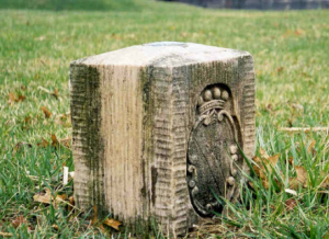
Many physical features of the old surveyed line still exist today. Every five miles, a limestone block marked the surveyed line. The side facing Pennsylvania displayed the arms of the Penn Family and the Maryland side displayed the Calvert family arms. Many of these original stones still survive along the line today.

